International Frameworks for Disaster Risk Reduction: Useful Guidance for Sustainable Mountain Development?

Paper published by Markus Zimmermann and Margreth Keiler in Mountain Research and Development.

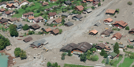
In recent decades, a number of global frameworks have been developed for disaster risk reduction (DRR). The Hyogo Framework for Action 2005–2015 and its successor document, the Sendai Framework for Disaster Risk Reduction, adopted in Japan in March 2015, provide general guidance for reducing risks from natural hazards. This is particularly important for mountainous areas, but DRR for mountain areas and sustainable mountain development received little attention in the recent policy debate. The question remains whether the Hyogo and Sendai frameworks can provide guidance for sustainable mountain development.

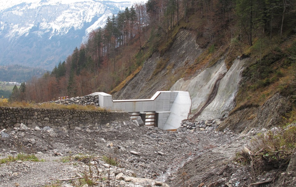
This article evaluates the two frameworks in light of the special challenges of DRR in mountain areas and argues that, while the frameworks offer valuable guidance, they need to be further adapted for local contexts—particularly for mountain areas, which require special attention because of changing risk patterns like the effects of climate change and high land-use pressure.

Paper published in Mountain Research and Development, Vol. 35, 2, 195-202.

NDR Consulting has been active (through SDC) in supporting the drafting process of the Sendai Framework for Disaster Risk Reduction (PDF) before and during the Sendai Conference.

Switzerland’s position on the post-2015 framework for disaster risk reduction

Framework

In the course of the consultations for a new DRR framework (HFA2) Switzerland established a firm position on the post-2015 framework for disaster risk reduction. Four key elements are essential to be strongly promoted:

(i) it is paramount to develop a comprehensive understand-ing of the disaster risk landscape; (ii) investors – be they public or private – must avoid building-up new disaster risks; (iii) existing risks should be further reduced based on a clear prioritization of risks; and (iv) governments have to create an enabling environment conducive to strengthening governance and accountability in disaster risk management. With contributions from many organisations (SDC, FOEN, FOCP, PLANAT) and individuals, an editorial board was requested to review the contributions and edit this position paper. NDR Consulting GmbH (M. Zimmermann) was member of this editorial board. Moreover, Markus Zimmermann actively participates in the policy discussions for this new framework.

The full paper can be downloaded from:

http://www.preventionweb.net/english/professional/publications/v.php?id=39037&cid=167

Kosovo Strategy for Disaster Reduction

The Kosovo Government (through UNDP) made an official request to PLANAT (www.planat.ch) for supporting the development of a strategy for disaster risk reduction. Following two exchange visits in February and April 2014 a first stocktaking workshop took place in early September 2014. During the three days’ workshop more than 30 representatives from various government agencies, UN agencies and NGOs discussed the prevailing risks in the country, available capacities to cope with these risks and subsequent disasters and identified gaps in today’s DRR system. Andreas Goetz (president of PLANAT), Christoph Werner and Markus Zimmermann (both members of PLANAT) participated from the Swiss side. PLANAT reconfirmed its commitment to support this process till a final draft of this strategy is reached and the process to build a Kosovo Platform for Disaster Reduction is initiated. Two messages by EMA (Emergency Management Agency) about the exchange visit and the workshop can be found on:

http://ame.rks-gov.net/en/News/ArtMID/813/ArticleID/31

http://ame.rks-gov.net/en/News/ArtMID/813/ArticleID/38

DSC_0135

Flood Management Tool Series, Technical Document No. 20 published

Flood Maps are tools to visualize flood information for decision makers and the general public. These maps form the basis for developing flood risk scenarios based on land use, various environmental and climate conditions and including social and economic conditions. Flood maps in their various formats and scales are the basis for the planning and implementation of development alternatives.

Flood_MapsIn addition to the general objective of a flood map, special uses require specific information including maps that depict exposure to floods of various recurrence periods, flood risks, vulnerability and response information such as evacuation routes, safe high grounds, shelter areas etc that are of utmost importance in flood plains but also in coastal areas at risk of storm surges and tsunamis. Different methodologies are presented in the production of flood maps for various purposes to support decision‐making at all levels.

NDR Consulting GmbH compiled and edited the recently published tool with support from the Technical Support Unit of APFM, the UNOSAT team (Geneva) and Roberto Loat (Federal Office for the Environment, Switzerland).

Read Flood Management Tool Series, Technical Document No. 20 on apfm.info.

Wasserbauprojekte Glyssibach and Trachtbach eingeweiht

Am 23. August 2005 kamen bei Murgängen im Glyssibach und im Trachtbach zwei Menschen ums Leben und es entstanden Sachschäden in der Höhe von 80 Millionen Franken in zwei Dorfteilen von Brienz.

Genau acht Jahre nach den verheerenden Unwettern wurden die Hochwasserschutzbauten in Brienz eingeweiht. NDR Consulting war von der Analyse des Unwetters, der Erarbeitung des Sicherheitskonzepts  bis zur Fertigstellung der Schutzbauten regelmässig involviert: zum Projektbeschrieb

20101110_Glyssibach_007


In den Medien: